Land Surveys
Land Registry Compliant Plans & Determined Boundary Plans

A Land Registry Compliant Plan (also commonly known as a boundary plan, lease plan, deed plan or conveyance plan) shows land or property that is subject to a Land Registry application. When land or property is first registered, transferred or when leases longer than 7 years are created, an application must be made to the Land Registry. A Land Registry compliant plan will also be required as part of a determined boundaries application and be used to update the Land Registry on the precise location of a boundary following on from the resolution of a boundary dispute.
All plans submitted to the Land Registry must meet a required standard and will form part of the application, usually drafted by a solicitor or planning consultant.
Most plans held by the Land Registry are based on Ordnance Survey information which show general rather than exact boundary information and are subject to accuracy tolerances.
Onyx Land Consulting can provide highly accurate and detailed Land Registry Compliant Plans and Determined Boundary Plans by combining survey data obtained from up-to-date field measurements with data from existing sources (i.e. Land Registry and Ordnance Survey).
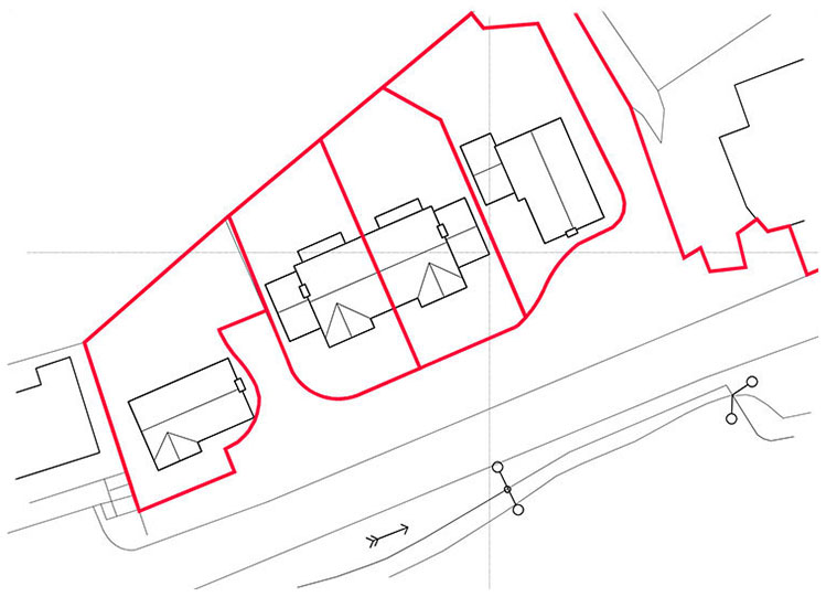 Land Registry Compliant Plan
Topographical Surveys
Topographical Surveys (or Land Surveys) gather data about the elevation points (or levels) on an area of land and present them as contour lines on a plot. The purpose of a topographic survey is to accurately represent all the natural and man-made features of the land, as well as its elevations on a scaled survey drawing.
Setting Out
A Setting Out Survey (or Construction Engineering Survey) includes setting out of primary control, building grid lines, level datums, roads, foundations and steelwork. It involves the extraction of data from drawings and plans, to then precisely mark out features on the ground surface that will guide the construction of new structures such as roads or buildings.
Volumes
A Volume Survey is a variation of a topographic survey where particular attention is paid to levels and break lines. A key element in any site development, volumetric surveys are used to accurately calculate and establish stockpile volumes, resources needed for extraction and volumes of earthworks.
Monitoring of Land or Structures for Movement
Monitoring Surveys (or Deformation Surveys) are undertaken to identify and map movement or deformation in buildings or land using precise digital levels, movement detectors and precision survey instruments. Depending on the application, monitoring surveys can be conducted in real-time or over long periods to demonstrate changes and trends.
Get in touch to discuss your land survey enquiries
Building Surveys
As-Built Surveys
As-Built Surveys are often commissioned during building and construction projects to confirm that the project has been constructed as per the original design or to record and identify variations. As-built surveys are carried out at the end of a project but can be carried out several times during construction to ensure all aspects of the project have been constructed correctly. They can be used to identify discrepancies or can indicate problem areas due to errors during construction.
Heritage Surveys
Heritage Surveys provide detailed and accurate 2D and 3D data on buildings, monuments and sites of historic interest. They are highly specialised, using the latest remote sensing technology and photogrammetry in order to minimise the risk of damage.
 Heritage Building Surveys
Measured Floor Plans & Reflected Ceiling Plans
A Measured Building Survey provides an accurate representation of the structure being surveyed (i.e. its shape and dimensions) in either 2D or 3D format. Measured floor plans and reflected ceiling plans can readily be generated from the measured building survey data.
Elevations, Cross Sections & Sectional Elevations
A Measured Building Survey can also be used to provide site-specific elevations, cross-sections and sectional elevations, depending on the requirements.
Areas - NIA, GIA & GEA
Calculations to determine areas within buildings are often required for purposes such as asset valuation, property management, planning or acquisition. They can be provided for separate rooms or entire buildings as part of a measured building survey, and are calculated using the following methods:
Net Internal Area (NIA) - the usable area within a building measured to the internal face of the perimeter walls at each floor level
Gross Internal Area (GIA) - the area of the building measured to the internal face of the perimeter walls at each floor level
Gross External Area (GEA) - the area of a building measured externally at each floor level
Get in touch to discuss your building survey enquiries
Other Services
3D Laser Scanning
3D Laser Scanning, also called High Definition Surveying (HDS), is a method of high-accuracy mapping or reality capture that uses laser beams to quickly capture complete detail of the entire surface or building - much like a camera taking a 360-degree photo, but with an accurate position for every pixel. This detailed 3D representation of the surface or building being surveyed is often called a point cloud.
Revit Modelling and Scan to BIM
Revit is Building Information Modelling (BIM) software that allows users to design a building or structure and its components in 3D, annotate the model with 2D drafting elements, and access building information from the building model's database. It is used by architects, structural engineers, MEP engineers, designers and contractors.
Transferring the digital representation of the site surveyed (i.e. the point cloud from 3D laser scanning) into the BIM software for use in designing and manipulation is referred to as Scan to BIM.
 3D Laser Scan to BIM
Underground Services and Utility Surveys
Underground Services Surveys or Utility Surveys are commissioned to ascertain the location, positioning and identification of buried pipes, cables, ducts, sewers, gas pipes and water surface drainage routes.
Dependent on the project requirement, several techniques can be used including CCTV Surveys, Electromagnetic Locators (EML) and Ground Penetrating Radar (GPR)
3D Visualisation and Walk-Throughs
Once a completed Measured Building Survey has been undertaken, the 3D model created combined with the latest Virtual Reality (VR) technology can be used to simulate the look and feel of being there.
For use in a variety of projects, such visualisations together with walk-through video enables the client to immerse themselves in the design concept whilst bringing blueprints to life – giving a true representation of space and design, with the capability to alter the plans in real-time.

Walk-Through Video
Commercial Property Development:
Renovation and Refurbishment Project
Drone Surveys and Aerial Photography
Drone Surveys (or UAV Surveys) are used in both land and building surveying from large scale agricultural areas to individual properties. Their use reduces health and safety risks in surveying potentially unsafe or hard-to-reach locations.
Drone surveys have several applications including high level inspection work, roof surveys and mapping services. They can be commissioned to gather accurate aerial data and high-resolution aerial photography of a particular property or region.
Aerodrome Surveys
Aerodrome Surveys are conducted to provide accurate positional information to enable aerodrome operators to meet their safety responsibilities and provide the data required by all stakeholders. They provide quality assured lists of aerodrome facilities (i.e. runways, navigation aids) and features identified as obstacles for each aerodrome.
Get in touch to discuss your enquiries



Contact

Tel: 0800 862 0802


© Onyx Land Consulting Ltd
Company No. 11612005
Registered in England and Wales.
Part of the
Business Critical Engineering Ltd Group